Monday December 28th - Day 8 of fly and drive trip to Oregon - Thermopolis WY to O'Neil Nebraska
I think and hope that today is the most difficult day of the entire drive home trip. I ended up just having a bath butt a really good one in my room. The mineral pools will have to wait until next time. Thermopolis was thermally minimal this morning (about 6 degrees) when I headed back down Wind River Canyon at about 6 am. The canyon was icy yesterday and I imagine it was still icy this morning so I drove cautiously. After the canyon there was a bit of mostly dry and clear pavement (easy fast driving) but after turning East in Shoshoni where US-20 and US-26 become one road, conditions got worse as I headed East. By the time I was half way to Casper it was basically an icy mess. It wasn't just icy spots but a constant silvery reflective glazing of ice that got worse the closer I got to Casper. Thankfully there were almost no cars until I got to Casper and since there was almost never another car around me and little opportunity for surprises on US-20, I felt ok going 45 or so most of the time. As with other areas that I drove in with bad conditions in this trip, going forward and normal gentle steering inputs were not difficult or nerve wracking but my little tests of braking ability consistently showed that the traction under my tires was really quite poor.
By the time I got to Casper it was just past sunrise and temps had dropped to about 0 degrees F. While there weren't a LOT of people driving around Casper, there were plenty of chances to see people fishtailing and skidding etc. One SUV came to a swerving skidding stop behind me. I wouldn't call it a near miss but it was near enough. East of Casper I stayed on US-26 and could see on Google Maps that I-25 was closed for many miles paralleling my route. As with everywhere else in Wyoming, the least populated state in the US, there were so few cars around that it was mostly nobody in front and nobody behind me which makes even really bad conditions a lot more manageable. US-26 would have become duplexed with I-25 at one point but since I-25 in that section was closed I went on an awkward desolate V shaped routing of WY-95 and WY-93 and THEN I got on I-25 for a few icy miles with some clearly freaked out people driving 35 with their flashers on until getting on US-18/20 which became just US-20 at Lusk Wyoming. At some point there was a very long coal unit train going the same direction and only a little slower than I was. It seemed like I was next to it for a long time.
All totaled, Thermopolis to the Nebraska state line was about 270 miles of icy roads. During the last few miles near the Nebraska border the ice finally became patchier and thinner. I pulled over at the border to take a picture of the Welcome to Nebraska sign for a coworker from Nebraska who lives in NJ. As I was getting out of the car I saw a Nebraska snow plow coming and it unsurprisingly drove right to the state line then turned around in the pull out on the opposite side of US-20 from me. I didn't see a single snow plow in Wyoming yesterday and only one in Wind River Canyon today so it probably wasn't magic that the snow and ice were nearly 100% gone as soon as I got into Nebraska.
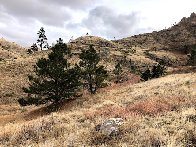
Brian and I stayed at Fort Robinson State Park on our 6 week mega road trip during our move to PA a few years ago. Since my route was taking me right through there again today I planned my day so that I would have the chance to revisit Fort Robinson today. It was around noon when I got into Nebraska so I went past it to have a delicious burger and fries lunch at Dairy Sweet in Crawford. None of the customer or staff were wearing masks so despite the near freezing temps, I ate my amazingly delicious greasy lunch in the car. Then I headed back to Fort Robinson to get some information about a hike and to enquire about a road I could see on Google Maps that appeared to run just North of US-20, snaking through some of the most dramatic hilly bluffs and forested land that makes that part of Nebraska such a stand out in a state not known for dramatic topography or forests. The hike we picked out for me was actually off of this scenic road appropriately called Smiley Canyon Scenic Road. The person at the state park lodge seemed friendly and they had one double-sided trail guide and 1 single page annotated aerial photograph, both printed in color. I paid my vehicle fee (8$) and headed out feeling confident that between the maps and my conversation, I should have had ample information to get to and do the hike. Unfortunately, neither map was particularly clear and the State Park doesn't see fit to have a sign on US-20 identifying the start of the one way scenic road. I eventually used Google Maps to find it and it was actually just a tiny distance from the Lodge and office of the park. The drive was very interesting and remote feeling. For the first few miles there were no pull outs or parking areas and when I came to the first one I was expecting to see the Buttes trail I had been told about. What I actually saw was one of two possible trailheads for an 8 mile difficult canyon loop and a trail called Turtle Rocks which wasn't on any of my maps. Not wanting to risk passing my trailhead and having to drive the one way road again, I opted to hoof my way up the very steep and beautiful Turtle Rocks trail. It was a very stiff sandy uphill trail and there were prickly weeds in spots but the views were worth it. On the way back by the main park entrance I decided to stop in to give the staff some feedback about the issues I experienced with their maps and signage etc. By the time I finished studying the maps I identified a long list of things that weren't good about them. I'll spare you a list of them because this entry is already ridiculously long and rambling but I had many gripes about the maps and the person I spoke to said she agreed with me that the maps were inadequate. She also said some of the trail network was 'new' to the state park. Maybe the scenic drive and its trails were previously managed by the Feds as part of the nearby Soldier Creek Wilderness?
It was just past 2 PM when I got on the road again to continue East on US-20 and the rest of the day, while high speed (65 or 70) and incident free, seemed endless. I ate a quick dinner at a Subway in the last town before O'Neil. I got to the hotel after 8 am. Losing an hour entering Central Time was not a plus but even without that it was a very very long day covering almost 600 miles. The Golden Hotel in O'Neil is charming and historic. It also has not one but two locations to do laundry and the front desk person was friendly and full of information, The TV is huge, the Wi-Fi is working great and the bathroom is stylish and contemporary. The only obvious negative is the lack of an elevator but I enjoyed being able to do laundry so late at night.
As a postscript to this marathon entry, I have an odd pattern of seemingly losing things but then having them (mostly) magically come back to me. Today I found my favorite face mask hiding in my gym/laundry bag after a month of being missing. A nice symbolic end to a long and challenging but genuinely rewarding day.


Comments
Post a Comment