Posts

Showing posts from 2018

2018 - Hike 37 - November 2 - Peaked Hill Pond Trail - Licoln, NH

Image
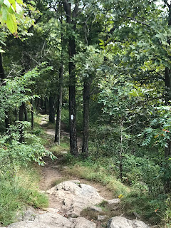
Peaked Hill Pond Trail Posted by Chris 11/10/18 Basics: Length - About 3.2 miles Elevation gain - About 450 feet Nearest city - Thornton NH? Difficulty - Easy The Day: We were on our way to Brian's brother's wedding at beautiful Mountain View Grand  hotel.  It had been a difficult day and we were both in a bad mood as we did errands and a longer than it seemed drive from Sturbridge MA.  This hike was very spontaneous since we had just a little bit of extra time before we could check in etc. The trail: Despite starting just inches off  of I-93, the hike quickly became a woody and peaceful experience with a modest but steady uphill incline.  The pond at the top was beautiful but none of our photos of it were great so I've skipped most of them. Photos by Brian

2018 - Hike 36 - October 21 - Nockamixon State Park - Quakertown, PA

Image
Various Nockamixon State Park trails Posted by Chris 11/3/18 Basics: Length - About 3 miles Elevation gain - Minimal Nearest city - Quakertown PA Difficulty - Easy The Day: We headed out to this park at the end of a busy day.  I had printed out the map etc for the hike a long time ago but had never made it to the park.  The drive was pleasant but the park was very wet. The trail(s): We tried walking along the trail below the large number of cabins the state has along the lake.  It was very wet and in many spots extremely muddy.  We ended up turning around and going back to where the car was to try going uphill away from the lake and at first that trail was considerably drier but later became a narrow ditch with water in the bottom which we had to walk duck legged along before becoming so muddy that we couldn't get around it without getting messy at which point we turned around again and tried the THIRD trail that led off from where the car was park...

2018 - Hike 35 - October 20 - Merrill Creek Reservoir - Harmony, NJ

Image
Various trails Posted by Chris 10/21/18 Basics: Length - About 3 miles Elevation gain - Minimal Nearest city - Harmony NJ Difficulty - Easy The Day: Brian had a ton of homework and other work to do this weekend so we made getting out for an afternoon hike a goal. The Trail: We walked around the reservoir on a few different colored trails.  We tried to do it a little different than we did the one other time we were at this park.  There were only a few other people hiking this day and it was very relaxing and, as the day required, close to home and fast. Pics by Brian

2018 - Hike 34 - October 5 - Falls in the River Trail - Pittsburgh, NH

Image
Falls in the River Trail Posted by Chris 10/21/18 Basics: Length - About 3 miles Elevation gain - Negligible Nearest city - Pittsburgh NH Difficulty - Easy with some tree roots The Day: A quick hike on the way from the camping to Brian's family.  Not far from Canada, this trail was probably built by the nearby Hydro electric project.  It was a woodsy nice walk with both moving and still water features. The Trail: Starting near the dam, this trail followed the river and was well graded and pleasant though there were a lot of tree roots. Pics by Brian.

2018 - Hike 33 - October 4 - Austin Brook - Shelburne, NH

Image
Austin Brook Trail Posted by Chris 10/13/18 Basics: Length - About 5.4 miles Elevation gain - 900 feet Nearest city - Shellburne NH and Gorham NH are near Difficulty - Moderate The Day: We arrived to our Yurt at Milan Hill state park very late on Wednesday night.  The weather forecast was for increasing chances of rain as Thursday went on so we got an early start and minimized our driving by going to Austin Brook which was less than 30 miles from our campsite. The trail: The trail starts of a very quiet side road with a very tiny parking lot that isn't marked.  Alltrails GPS pointed was essential for getting to it.  The trail as plotted went up the brook for about half a mile before making a seemingly illogical little diversion off to one side for no more than a quarter mile and then came back to the same trail and continued on.  Luckily I insisted we go look at the diversion because I figured there was something of interest there or they wouldn't ...

2018 - Hike 32 - September 30 - Ice Lake Park - Cresco, PA

Image
Ghost Lake, Summit and Orchard Trails Posted by Chris 9/30/18 Basics: Length - About 3 miles Elevation gain - none Nearest city - Cresco, PA is very close Difficulty - Easy The Day: After working all day Brian wanted to see I would meet him half way between home and work to squeeze in a qualifying hike at a new place he'd been aware of but not yet explored.  So we met up at the park and started wandering. The trails: There is a trail that goes around the lake but the small concrete dam's spillway wasn't bridged.  So we walked around the lake which was nice with some reflective pictures of the surroundings in the lake etc.  Then there was a blazed snow mobile tray that led off from one corner of the lake so we followed that until it seemingly ended at a Cresco community park/field with baseball diamonds etc.  Walking back from that point wouldn't be enough mileage so at a spot where the blazed trail made a 90 degree turn we went the opposite directi...

2018 - Hike 31 - September 29 - Jenny Jump State Park - Hope, NJ

Image
Ghost Lake, Summit and Orchard Trails Posted by Chris 9/30/18 Basics: Length - About 5.5 miles Elevation gain - 1200 feet Nearest city - Hope, NJ is nearby Difficulty - Moderate with lots of hills The Day: There were other things that needed to happen Saturday besides a hike and we didn't get a super early start.  So I turned to one of the very closest substantial hikes we know of.  We did this hike once before but I don't think it was 2018. The trails: The hike is sort a reverse balloon.  You start near the bathrooms in the campground and then walk the park road downhill for a few minutes before beginning to climb as the gravel road is left behind and the real trails begin.  As a fitness walk this is a very good hike with nice periods of moderate climbing alternated with rolling ridgelines and at least this time, a ton of minor streams to cross.  The biggest detractor for this hike is that I-80 is painfully close and can be heard for about 2/...

2018 - Hike 30 - September 9 - Minnewaska State Park Preserve - Kerhonkson, NY

Image
Rainbow Falls Loop Posted by Chris 9/9/18 Basics: Length - About 5.5 miles Elevation gain - ~700 feet Nearest city - I'd call this a semi isolated area but Kerhonkson wasn't very far away Difficulty - Moderate with some difficult spots requiring VERY good agility The Day: We headed out very early today.  It was 100 miles away but that was about where the chance of rain went down from 100% to 20%.  It worked, there was no rain at this place.  We initially were headed for a location that was in a preserve managed by some sort of foundation.  The trail guide on Alltrails looked good but when we got there we found out it was 15 dollars PER PERSON to go into the Mohonk preserve.  So we took the toll collector's advice and went to the state park up the road.  Then Alltrails hit it out of the park and found a beautiful interesting loop trail with no crowds (there were a ton of people at the park but most of them went to some other waterfall and we...

2018 - Hike 29 - September 8 - Hacklebarney State Park - Chester, NJ

Image
Hacklebarney State Park loop Posted by Chris 9/9/18 Basics: Length - About 3 miles Elevation gain - Maybe 300 feet Nearest city - Chester/Long Valley NJ Difficulty - Easy but a fair amount of rocks and roots near the river The Day: We took our friend Bob out with us this trip.  We wanted to make sure it was a fairly easy and short hike since we didn't head out until 9 am and Bob doesn't hike often.  We ate breakfast at Panera in Hackettstown then over Schooley's mountain towards the park.  The car GPS initially took us to the back side of the park and we took a few  miles of gravel roads to get to the GPS coordinates provided in the trail guide that I should have punched in from the start but we were still hiking by about 10:40 am.  There were only a very few cars at the lot which made for a peaceful hike free from summer's crowds. The trail: The trail loop basically goes along the Black river on one side then back on the other side but to get...

2018 - Hike 28 - September 2 - Stokes State Forest - Montague, NJ

Image
Appalachian Trail to Sunrise Mountain Pavilion Posted by Chris 9/2/18 Basics: Length - Over 7 miles Elevation gain - Estimated at 500 feet delivered in many small ups and downs Nearest city - Montague isn't very far from the trail head and High Point State Park was very nearby Difficulty - Moderate The Day: We headed out about 9 am and arrived at the trail head by 10.  The guide we used had GPS coordinates for the starting point which is very helpful. The trail: This section of the AT was very enjoyable. Other than the road where we parked there were no road crossings and we didn't spot a single speck of litter or hear any intrusions from civilization which was great.  Though the trail guide said there wasn't much elevation change, there were actually a lot of ups and downs even if none of them were very long.  It was a little humid and warm but we still enjoyed the hike immensely.  On the way home I tried following CR-519 home all the way. ...

2018 - Hike 27 - August 25 - Washington Crossing State Park - Titusville, NJ

Image
Various trails in and near park including Delaware and Raritan Canal Trail Posted by Chris 8/30/18 Basics: Length - 4 miles Elevation gain - 200 feet Nearest city - Titusville is pretty close to Trenton Difficulty - Easy hiking with some navigational challenges The Day: My goal was to get to Haddonfield NJ to see the Indian King Tavern Museum  and I heard Haddonfield has an interesting downtown.  We did make it to both the museum and downtown and both were worth seeing.  On the way down I tried to take some side roads and we were on NJ-29 for quite a while.  Brian was longingly looking at the canal's walking path and when I saw the signs for Washington Crossing I knew I finally had a chance to visit this park which has been on my to-do list even if our visit was more serendipitous than planned. The trail: We walked along one of the historic paths that Washington's army used from the visitor's center over to the canal and then walked North along the...

2018 - Hike 26 - August 24 - Prompton State Park - Prompton, PA

Image
East Shore Trail Posted by Chris 8/24/18 Basics: Length - 4 miles approximately hiked out of a 5.3 mile loop planned Elevation gain - 300 feet Nearest city - Prompton, PA (West of Scranton about 20 miles near US-6) Difficulty - Moderate terrain with some wet conditions today The Day: We were in Scranton to have one of the cars serviced.  Rather than having one person go to the dealership and sit around all day bored we both took the day off, both drove to Scranton in separate cars and then took off in the other car for the hike.  We started our hike about 10:20 using the Alltrails map for this hike. The trail: This was our second visit (ever) to Prompton state park.  It is one of the less developed PA State parks (no bathrooms, no camping areas etc as far as I know) and it feels pretty remote with just a small gravel parking lot and not much signage.  This does not detract from my opinion of the park at all!  With 26 miles of trails and a var...

2018 - Hike 25 - August 11 - Warwick City Park - Warwick, RI

Image
City Park Trail Posted by Chris 8/24/18 Basics: Length - 3 miles Elevation gain - None Nearest city - Warwick, RI Difficulty - Very easy The Day: We were visiting Brian's family in RI and did mange to get one qualifying walk into what was a rainy and humid weekend.  The walk was very relaxed and easy until it started raining at which time we picked up the pace a bit. The trail: The trail goes out around a loop and at one point it goes right up to the shore looking across the bay separates Warwick into two separate peninsulas.  The shore view was probably the highlight of this basic walk.