Posts

Showing posts from March, 2022

Sunday March 27th, Keshequa Creek Falls, near Sonyea NY, 4 miles, about 300 feet elevation gain

Image
I set out for us to do a 4.9 miles hike at Letchworth State Park but only after getting to the main entrance to the park did we realize that the hike I selected was actually at the south end of the park, about 30 minutes away.  I found this as an alternative hike and only when we arrived at the trailhead did I realize that this was a trail we actually did before.  I couldn't find a write up for it so I guess we didn't document it.  This is one of those trailheads that is tricky to get to.  Google Maps tries to send you through state penitentiary grounds.  The work around for that is a long bumpy dirt road.  It wasn't such a bad time to be in a truck.  We saw nobody else on this walk.  The trail starts by going down a steady slope almost to the creek with a short but very steep section at the very bottom. From there the trail parallels the creek. The end of the trail is a spot where there are posted no trespassing signs in one direction and a minor overgrown trail.  That was

Monday March 21st, Channing Philbrick Park, Penfield (Rochester) NY, 2 miles, modest elevation gain

Image
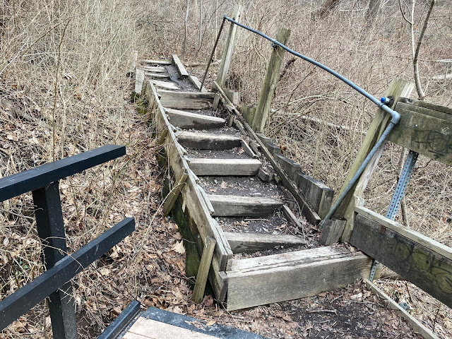
 This was a quick after work hike.  Brian had to come home early for a dental appointment and when that was done we were able to head out around 3:30 which was a good opportunity to go somewhere that might ordinarily be a little too popular for our tastes.  This was a hike we did once before but this time we stayed near the creek and didn't climb the hill that overlooks the park.  We did get to go farther back in the park than we did the other time when it was more crowded. The creek was a roaring torrent of water which is why I picked this park on this day.  It was very relaxing to listen to and it's cool this park is practically in urban Rochester.  The crazy funhouse quality stairs haven't been repaired.

Saturday March 19th, Sustainable forestry trail near Pennsylvania Lumber museum, Galeton PA, About 2 miles, minimal elevation gain

Image
 This was a long drive for a short hike.  but I'd come here once before alone and was struck by how beautiful the scene was around the museum. The creek that flows along the trail is gorgeous and, unusually, it has almost no gorge. It's almost like it runs along the ground in almost no depression. We also made a quick pass through the museum, to pay admission as much as anything.  It was a very peaceful enjoyable day and I'm glad we took the Cruze because it was a long drive and the gas eaten in our loaner Ram pickup would have been expensive! 

Friday March 18th, Conklin Gully Trail, High Tor WMA, about 2.1 miles, 520 feet elevation gain

Image
 This was a solo hike after work.  We've done other hikes in the High Tor area.  This one sounded great, it's only 2 miles long but has over 500 foot elevation gain.  This turned out to be quite a stiff little hike.  It starts almost at lake level (near the Southern end of the finger lake Canandaigua) and climbs high above the lake to the top of a bluff.  There is a remarkably deep narrow gorge that a creek flows through.  I was actually holding onto some trees at one point to get a closer look over the precipitous edges.  To say this hike has fall hazards would be putting it mildly.  There are also spots where the water flows swiftly over bare rock very very far below the trail and would be almost impossible to get to.  Pretty wild stuff in a relatively unknown minor park.  I hiked in what would appear counter clockwise on the map shown below.  A stellar quick walk.

Thursday, March 17th, Wesley Hill nature preserve near Naples NY, about 3.6 miles, 600 feet elevation gain estimated

Image
 This nature preserve is, by far, the most frequently repeated place to hike for us since we live in New York.  This was a solo after work trip. I'm really appreciating having it be light so much later post spring forward time change.  There are about 5 different trails that can be done separately or linked together at this gem of a park.  From the parking lot, the trail we use most often goes relatively steeply downhill briefly before flattening out down near a pond.  After walking around the pond this same trail (red trail?) continues downhill farther following a deep gorge which has a lot of water and half frozen waterfalls at this time of year.  The trail then comes to an old homesteader's cabin.  From the cabin we usually either walk back up the gully and up the other hill back to the car OR take the yellow trail which makes a more meandering course across a modest hill.  I love the wandering yellow trail and take it almost every time one direction or another. As if often

Saturday March 5, Klondike State Forest near West Amboy NY (North of Syracuse) - About 2 miles, modest elevation gain

Image
 This was a very wintery hike.  There was going to be some snow no matter where we went but there was a LOT of snow at this particular spot.  We parked at the junction of 2 dirt roads.  There were a number of hunters there with about 5 vehicles, one of them with a dead wolf draped on it.  The hunters seemed wary of us but we walked by them without interacting.  This is one of those hikes in the 50 Hikes in Central NY book where the author has you walk half a mile down a road then a quarter mile off on a side trail to see some field then back to the main road and on another half mile to see some minor vista before retracing slightly to go on some other trail.  We made some effort to follow these directions but really everything was deeply covered in snow so the stone wall we were supposed to see etc was all buried.  The weather was crisp and it wasn't windy.  We didn't cover a lot of miles but it was good exercise because the main road had deep snowy ruts and the side trails wer